Land Surveying New Bedford, MA: Downtown, North End Services
Coastal properties in New Bedford, Downtown, North End, South End, and West End require accuracy, compliance, and local environmental awareness. Mass Land Surveying provides land surveying services. Utilizing advanced GPS receivers, robotic total stations, and RTK technology, our licensed surveyors deliver precise measurements essential for coastal developments throughout New Bedford, Downtown, North End, South End, West End and the Cape Cod region—including boundary, topographic, FEMA elevation, and wetland mapping. Our licensed team combines precision technology with coastal expertise. We employ Leica total stations and Trimble GNSS systems alongside AutoCAD Civil 3D software to produce accurate CAD files and GIS layers compliant with Massachusetts standards, to help clients navigate permitting and construction near sensitive areas. Our team recently completed boundary surveys. These boundary surveys involved retracing metes and bounds descriptions from historic deeds, setting property corners with rebar monuments, and preparing sealed plats for zoning compliance. for residential projects near Union Street in Downtown and along Acushnet Avenue in the North End, ensuring compliance with local zoning near the historic waterfront.
We've also provided topographic mapping for developments. Our topographic surveys capture contours at 1-foot intervals, locate utilities and drainage features, and integrate orthophotography for comprehensive site planning. off County Street in the West End and FEMA elevation certificates for properties. These certificates are generated using digital levels and FEMA-compliant benchmarks, ensuring accurate first-floor elevations for flood insurance and NFIP compliance. adjacent to the South End's Buttonwood Park, demonstrating our deep familiarity with New Bedford's unique neighborhoods and coastal regulations.
Quick Facts on New Bedford Land Surveying
- Service area: New Bedford, Downtown, North End, South End, West End, MA and surrounding Cape Cod towns
- Projects: Residential, commercial, environmental, and municipal
- Deliverables: CAD files, sealed plans, GIS data, and FEMA Elevation Certificates
- Availability: Standard and expedited service options
Boundary & Property Line Surveys New Bedford MA
Define property ownership clearly and prevent costly disputes.
Construction Staking & Site Layout
Translate your plans into precise field positions that keep builds on track.
Topographic & GIS Mapping
Visualize terrain and infrastructure for smarter planning.
Wetland & Environmental Surveys
Stay compliant with Massachusetts and federal environmental regulations.
Local Land Surveyors in New Bedford, Downtown, North End
Mass Land Surveying’s experience spans coastal neighborhoods, harborfront parcels, and inland development sites across New Bedford, Downtown, North End, South End, West End—from Downtown and North End to New Bedford, Downtown, North End, South End, West End Village, and along Route 6. Our team understands the permitting complexity associated with Cape Cod Commission standards, Conservation Commission approvals, and FEMA floodplain compliance.
Recent Example: Mass Land Surveying completed a topographic and elevation certificate survey for a residential rebuild along New Bedford, Downtown, North End, South End, West End Harbor. The project required coordination with FEMA flood zone mapping, local Conservation Commission review, and integration with architectural site plans—ensuring the client achieved compliance and insurance approval.
Core Land Surveying Services New Bedford, MA
Boundary & Property Line Surveys New Bedford, MA
Define accurate property boundaries for sales, improvements, or permitting. Includes deed research, monumentation, and certified plans.
Topographic & Site Mapping New Bedford, MA
Detailed terrain and feature mapping for design, grading, drainage, and coastal construction. Delivered in CAD and GIS formats.
FEMA Elevation Certificates New Bedford Floodplain Mapping
Certified elevation data for FEMA flood compliance, insurance, and coastal permitting.
Wetland Mapping New Bedford, MA, MassDEP Compliant
Accurate wetland delineations, resource area mapping, and buffer coordination with environmental consultants to support filings under the Wetlands Protection Act and Coastal Zone Management policies.
ALTA Surveys New Bedford, MA Land Title
Lender- and title-ready surveys meeting national standards, ideal for Cape Cod commercial and redevelopment projects.
Construction Layout Staking New Bedford MA
Precise control and layout services for contractors and site development projects—supporting foundations, utilities, and grading.
Why Choose Land Surveyors New Bedford, MA
- Coastal expertise: Familiar with FEMA, CZM, and MassDEP permitting
- Advanced tools: GNSS/RTK and total station precision for challenging terrain
- Regulatory alignment: Plans formatted for local boards and agencies
- Responsive support: Quick turnaround and clear project communication
“Mass Land Surveying’s survey helped us secure our elevation certificate and complete our rebuild on schedule.” — Cape Cod Homeowner
Our Land Surveying Process, New Bedford, MA
- Scope & Quote – Confirm use, schedule, and deliverables.
- Records & Research – Review deeds, benchmarks, and flood data.
- Field Survey – GNSS/RTK and level data collection.
- Computation & Drafting – CAD/GIS production with QA.
- Certification & Delivery – Sealed plans, FEMA forms, and GIS data.
- Follow-Up Support – Layout or additional documentation if required.
Industries for Land Surveying New Bedford, MA
- Residential: Boundary, topographic, and elevation surveys
- Commercial: ALTA/NSPS and site design support
- Environmental: Wetland delineation and buffer mapping
- Municipal: Utility and infrastructure surveys
- Coastal Projects: FEMA compliance and shoreline development
Land Surveying New Bedford, MA & Nearby Areas
- New Bedford, Downtown, North End, South End, West End (all villages)
- Downtown • North End • South End • West End • West End • North End
Don’t see your village? Contact us—we likely serve your area.
Expected Deliverables Land Surveying New Bedford
- Signed/sealed plans (PDF + hard copy upon request)
- CAD (DWG/DXF) and GIS shapefiles
- FEMA Elevation Certificate (when scoped)
- Control reports and coordinate data
Compliance & Quality Land Surveying New Bedford
- FEMA, MassDEP, and CZM standards
- Local Conservation Commission submittal formatting
- Clear legends, basis of bearings, and flood elevation notes
- Peer-reviewed QA for all deliverables
Land Surveying FAQs New Bedford, MA
Do you perform elevation certificate surveys in New Bedford, Downtown, North End, South End, and West End?
Yes—our licensed surveyors provide FEMA-compliant elevation certificates for coastal and flood-prone properties.
Can you handle wetland delineation and mapping?
Yes, we coordinate with environmental specialists and flag wetland resource areas in compliance with MassDEP and CZM standards.
Do you work on residential and commercial sites?
Absolutely—Mass Land Surveying serves both homeowners and developers throughout Cape Cod.
How fast can I get a survey?
Most residential and elevation surveys are completed within 1–2 weeks, depending on access and research.
Get Your Land Surveying Quote New Bedford
Tell us about your New Bedford, Downtown, North End, South End, and West End sites
- Property address or parcel ID
- Purpose (FEMA, design, construction, or sale)
- Timeline or critical dates
- Any past plans or deeds (attach if available)
Call Us: (508)-500-6755
Response time: Same or next business day
ALTA/NSPS Land Title Surveys in Massachusetts
ALTA/NSPS Land Title Surveys Commercial and institutional projects demand precision, compliance, and reliability. Mass Land Surveying provides …
As-Built & Record Surveys in Massachusetts
As-Built & Record Survey Services Every project needs precise documentation at completion. Mass Land Surveying provides As-Built and Record …
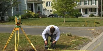
Boundary & Property Line Surveys in Massachusetts
Boundary & Property Line Surveys Defining your property boundaries is the foundation of every successful project—whether you’re building, …
Civil & Site Engineering in Massachusetts
Civil & Site Engineering Services Mass Land Surveying provides full-service civil and site engineering solutions to help clients plan, design, …
Construction Layout & Staking in Massachusetts
Construction Layout & Staking Services Accurate layout is critical to keeping your project on schedule and within tolerance. Mass Land Surveying …
Environmental Consulting & Remediation in Massachusetts
Environmental Consulting & Remediation Services Mass Land Surveying offers comprehensive environmental consulting and remediation services …
FEMA Elevation Certificates & Floodplain Mapping in Massachusetts
FEMA Elevation Certificates & Floodplain Mapping Services Floodplain compliance and accurate elevation data are critical for both safety …
Permitting & Regulatory Coordination in Massachusetts
Permitting & Regulatory Coordination Services Navigating Massachusetts permitting requirements can be complex. Mass Land Surveying provides …
Septic System Design & Redesign in Massachusetts
Septic System Design & Redesign (Title 5 Engineering) Proper septic design is critical to protecting both property and the environment. Mass …
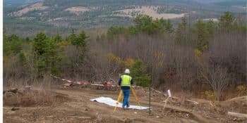
Solar Field Surveying & Civil Engineering in Massachusetts
Solar Field Surveying & Civil Engineering Solar development requires accuracy, coordination, and compliance. Mass Land Surveying provides …
Topographic & Site Mapping in Massachusetts
Topographic & Site Mapping Services Topographic and site mapping is essential for any design, planning, or engineering project. Mass Land …
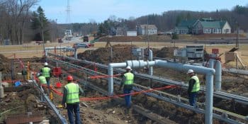
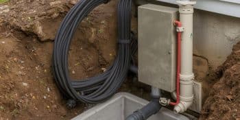
Utility & Infrastructure Surveys in Massachusetts
Utility & Infrastructure Survey Services Utility and infrastructure projects demand accuracy, reliability, and coordination. Mass Land Surveying …
Wetland & Environmental Mapping in Massachusetts
Wetland & Environmental Mapping Services Environmental permitting in Massachusetts demands precision and regulatory awareness. Mass Land …
Professional Land Surveying Services in Massachusetts
Professional Land Surveying Services in Massachusetts At Mass Land Surveying, we provide full-service land surveying across Central, Southeastern, …